Our 9 days trip had entered the last two days. I felt a little bite tired but was still enthusiastic in visiting new places. These new places would be pined on my maps once I had finished. It was a sort of travel and life achievement. Our journey for this day was to visit Capital Reef National Park. You might have guessed this. It was not as attractive to me as Arches National Park. I had no idea about this park before we headed on the road. My husband told me it was formed by water erosion geologically. I was totally depended on my husband when we traveled in the States. It was a carefree travel experience and I enjoyed it.
 |
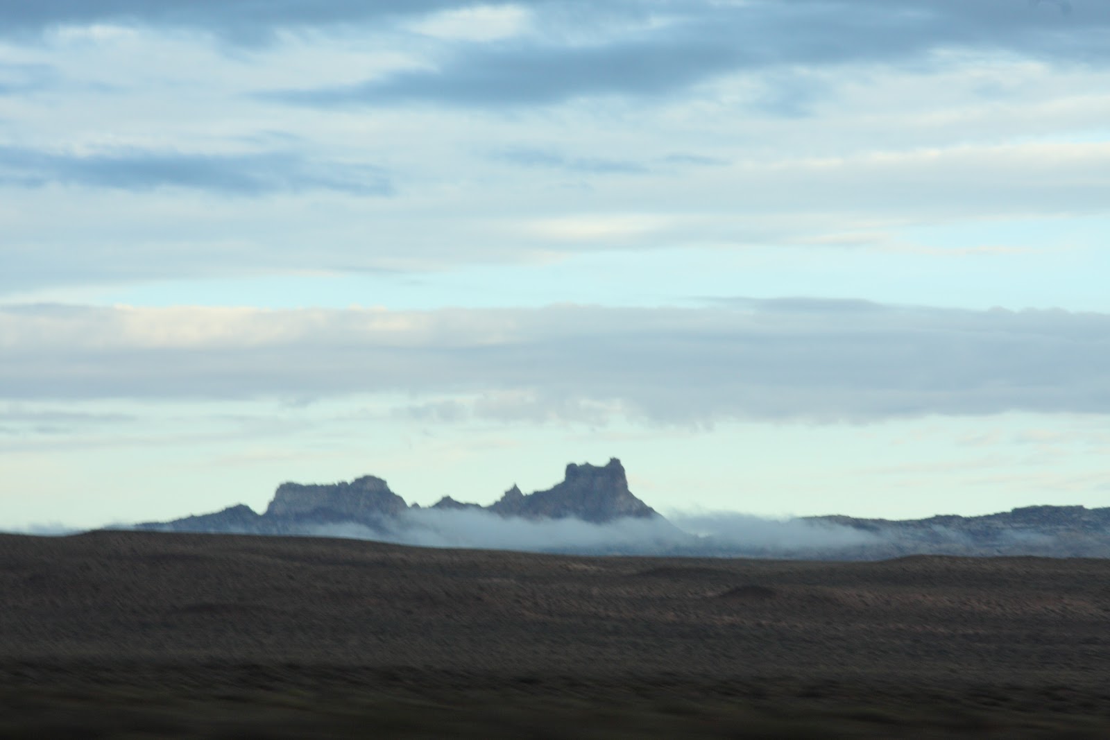
West of I-70 near Green River
There was still a lot of moisture in the sky. We didn't have any complaint about the weather because we had good weather for the past 6 days. We were lucky even when it rained on the prior day.
|
 |
| The clouds were so low which became a veil partialy covering the far away mountains in the high plains. It gave the atmosphere a sense of mystery. |
 |
| Sand dune on the road side |
 |
| We were heading into the storm. I worried about it may cause flooding on the way to the national park. However we had another different view. |
 |
| We went through the storm and the road conditions were just fine. The river became muddy after the storm. |
 |
I had no idea if we had passed the fee booth or not. I was just enjoying myself and the views. Did we have the park map?
"The most scenic portion of the Waterpocket Fold, found near the Fremont River, is known as Capitol Reef: capitol for the white domes of Navajo Sandstone that resemble capitol building domes, and reef for the rocky cliffs which are a barrier to travel, like a coral reef." |
 |
| I asked my husband to stop here since there were some vehicles parked there. Why not just get out of our car and see what there is to do around this area. The evidence of the rain reflected from the huge mountains and the sky in its small world. "Less than 0.25 inches (0.6 cm) of rain can produce flash floods. Flash floods are caused by run-off from intense, localized thunderstorms that drop a large amount of rain over a short period of time. They are most common in Capitol Reef in July, August and September, but can occur at any time of the year." from the park office website. |
 |
| After studying this map, we decided to take the hike to Hickman Bridge. |
 |
| A one mile one way trail sounded easy. But the elevation change (400 feet) was dragging my energy away. I felt it was a little bit difficult to walk up the trail stairs. The park brochure indicated this first part of the trail is strenuous which had "steep grades, uneven terrain and long steady climbs." |
|
|
 |
| Once we reached the top, the view was gorgeous. |
 |
| After the first strenuous part of the trail, we entered the moderate "mixed steep and level grades" trail. One thing that bothered me was there was no shade along the trail. My forearm which had already gotten sunburned would get worse, even thought the sun was not too bright in the early morning sky. |
 |
| The stones at this terrace were black. We doubted if they were volcano rocks or because the color was caused by a fire. After some researches, the park called these black rocks as black boulders. |
 |
| This was the sediment which built up Capital Reef. | | |
|
"Nearly 10,000 feet of sedimentary strata are found in the Capitol Reef
area. These rocks range in age from Permian (as old as 270 million years
old) to Cretaceous (as young as 80 million years old.) .....Rock layers in
Capitol Reef reveal ancient environments as varied as rivers and swamps
(Chinle Formation), Sahara-like deserts (Navajo Sandstone), and shallow
oceans (Mancos Shale)" from Capital National Park website.
 |
Finally, we arrived at the Hickman Bridge which is " a 133 foot natural rock."
|
|
|
 |
| Behind the Hickman Bridge, we saw a beetle resting on the top of the rock. Actually, it was a loop trail but we decided to walk back on the same trail. |
 |
| One female ranger and two workers carried a sign walking up the trail. It would not be an easy job to me. |
 |
| A group of young girls were full of energy carrying their camping gear. I am no longer fit in this lifestyle. It would be nice to be young again |
 |
| This was a nice wooden trail which took visitors to see the Indian rock arts. Most of the trail was under trees which gave visitors a cool breeze and was in the shade. |
 |
| It was not easy to spot the Indian rock arts on these giant rock walls. It was easy for more than two people to find the spots. |
 |
| This was the Fruita Schoolhouse which was built in 1896 and provided services for 8 farm families. The school closed in 1941 because of a lacking of students. |
 |
| Visiting the visitor center (the background was the Castle. ) |
 |
| Because of the rain which caused the flood the day before, the park's scenic drive was closed. The park worked hard to clean up the dirt and mud on the road and was expected to open in the afternoon. Visitors flowed into the service center for purchasing souvenirs and watching a short park introduction video. |
 |
| Although the scenic drive was closed, the road to the historic Gifford Homestead still remained open. We learned the house was convert to a sales outlet which sold some homemade products. We definitely didn't want to skip this site for the homemade type of food. |
 |
These jars with different flavors were made from local fruits.
We purchased one jar of peach butter to bring back to Taiwan. |
 |
| A homemade pie and ice cream were our lunch. |
 |
| I was attracted to these huge trees next to the picnic area. The massive branches and shapes let me feel like walking in a black forest that the tree elfin would create a maze to confuse all travelers. |
 |
| This view was awesome but I didn't know what it was called. It is called the Castle. |
 |
| This was me during our travels on the road. |
 |
| We decided to drive to our hotel and waited for the scenic drive to open in the afternoon. |
Scenic Drive:
 |
| We returned to the park after 5:30 pm to visit the scenic drive which was closed due to the flooding in the morning. |
 |
| This was the entrance to the scenic drive. There was a US$ 5 fee charge at this point. This photo was taken in the morning and the gate was closed. |
Scenic Drive Map
 |
| According to the park information, it was about a 90 minutes round trip drive. Also it listed 11 stops along the way to see its unique geological formation. Please visit Guide to the Scenic Drive for more introduction on this route. |
 |
| Driving on the road, we saw some places with the remains of the mud and dirt which was caused by the flash flood. |
 |
| This couple did enjoy their supper in the beautiful sunset in the natural environment. Because we visited this scenic drive in the late afternoon, there were not a lot of tourists in the park. We enjoyed the quiet moment with gorgeous scenery. It reminded me of our romantic moment in Bryce National Park where we were sitting in our camping chairs, a nice bottle of wine, a small table with a candle. We were enjoying the million dollar view on the rim trail at sunset. It was a fantastic memory in my wife. |
 |
| This was Eph Hanks Tower which was at the end of the paved road. The road (unpaved) to Capital Gorge was closed. |
 |
| Along the road we saw some enthusiastic photographers setting up their tripods for taking the terrific sunset views. My hands were my tripod which sometimes was not steady. |
 |
| Any explanation of this view was worthless and without words. |
 |
| My husband always told me that if I want to see wild animals, the best time of the day is during the twilight. So wake up early in the morning for the view. Well, I like to see the animals in the late afternoon, so I don't have to wake up early in the morning. This is one of our differences in our marriage but was still twilight. |
 |
| After we drove here which was called the Sunset Point, I realized this place was the best place to take sunset photos. I saw professional photographers walking back to their vehicles. This was the result of not studying the park. This was another excuse for coming back to the park. |
 |
| We met a couple who were from Hawaii. The lady was also from Taiwan. They were stargazers. We exchanged our travel experiences and had a great conversation with them. This was one of travel benefits for learning different point of views and knowledge. |
 |
| Good night and goodbye, Capital Reef National Park. |


I must say, those view deserves some credit in terms of freshness and beauty.
ReplyDeletePlaces to Stay in Bryce